wilkes-news
Magnesium Pollution?

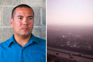
Salt Lake City, Utah
Research helps explain Salt Lake City's persistent air quality problems.
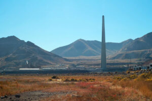
The 2.4 million people who live along Utah’s Wasatch Front experience some of the most severe winter particulate matter air pollution in the nation. Now, analysis of measurements taken during National Oceanic and Atmospheric Administration (NOAA) research flights in 2017 indicates that emissions from a single source, a magnesium refinery, may be responsible for a significant fraction of the fine particles that form the dense winter brown clouds that hang over Salt Lake City.
The finding was published this week in the journal Environmental Science and Technology.
Lead author Carrie Womack, a scientist with the Cooperative Institute for Research in Environmental Sciences at the University of Colorado Boulder working at NOAA, said analysis of airborne measurements directly from the plume rising from the US Magnesium refinery during a 2017 winter air pollution study in Utah found that emissions of chlorine and bromine, known as halogenated compounds, were significant contributors to the persistent winter brown clouds.

Carrie Womack
“I was struck by the complexity of chemical reactions in the atmosphere,” said U professor John Lin, of the Department of Atmospheric Sciences and a co-author of the study. “Changes in the chemical ingredients of the atmosphere could lead to unexpected outcomes through inter-linked chemical pathways.”
US Magnesium, the largest magnesium producer in North America, extracts the metal from the brine of the Great Salt Lake, at a plant upwind of Salt Lake City.
Particulate matter contains microscopic solids or liquid droplets that are so small that they can be inhaled and cause serious health problems. Particles less than 2.5 microns in diameter, also known as fine particles or PM2.5, pose the greatest risk to health, affecting both lungs and your heart.
“Understanding what causes this PM2.5 formation is the first step in reducing it,” Womack said. “One aspect of our study was characterizing known point sources in the area.”

John Lin
The Utah Division of Air Quality requires reporting of particulate precursors, such as chlorine and nitrogen oxide emissions, which are then shared with the US Environmental Protection Agency. However, NOAA’s measurements also identified significant emissions of bromine, a reactive chemical that is not required to be reported. Modeling demonstrated that the chlorine and bromine emitted by the refinery were responsible for 10 – 25% of regional PM2.5 during winter pollution episodes.
“Our measurements of chlorine and nitrogen oxides agree with what the facility reports to regulators,” Womack said. “But what we found suggests that bromine industrial emissions may deserve a closer look.”
Pollution control regulations and cleaner technologies adopted since the 1970s have steadily improved air quality in the US. Yet some valleys in the Intermountain West still experience high levels of PM2.5 during winter. In Utah’s urban Salt Lake Valley, wintertime levels of PM2.5 exceed national air quality standards an average of 18 days per year. The majority of exceedances occur in December, January and early February during a period when strong, multi-day inversions known as persistent cold air pools develop that trap pollution close to the surface.
These exceedances have been specifically associated with adverse health effects in the region, including a 42% higher rate of emergency room visits for asthma during the latter stages of air pollution events from 2003-2008, according to one study.
Prior to the NOAA study, the chemical composition of PM2.5 in northern Utah, and how it forms, had received considerably less attention than in other regions of the nation despite the severity of the problem in Utah.
“We could see during our research flights in 2017 that the air around the plant was unlike anything we had sampled previously due to the high chlorine emissions,” said NOAA scientist Steven Brown, who led the field campaign. “We were surprised that it had such a large effect on winter PM2.5 across the entire region.”
“Close to the plant, we didn’t even need to check the instruments to know we were flying through the plume,” Womack added. “We could smell it. It smelled like bleach!”
The dominant contributor to regional particulate matter is ammonium nitrate, which is responsible for up to 70% of fine particulate mass during inversion periods and 40% outside of inversions. Ammonium nitrate is a secondary pollutant formed by reactions between ammonia, nitrogen oxides (NOx), and volatile organic compounds (VOCs). The NOAA model demonstrated that halogen emissions from US Magnesium speed up the conversion of NOx and VOCs to ammonium nitrate particulate matter.
Researchers have shared their findings with Utah officials, who had sought NOAA’s help in understanding their poor winter air quality. A previous paper by Womack in 2019 documented other sources of winter smog.
The Utah Department of Environmental Quality is currently conducting a study to identify sources of ammonia.
While the new paper is based on measurements taken in 2017, Womack said emissions of chlorine, which accompany the unreported emissions of bromine, have not shown any sign of significant decline in the last five years.
Researchers from the University of Utah, the University of Toronto, the University of Washington, and the U.S. EPA also participated in the study.
Find the full study here.
CAPE-K

Gerald “Jay” Mace
U researcher to lead study of clouds in cleanest air on Earth.
The Southern Ocean is a remote region of the world that holds significant influence over the Earth’s climate. Compared with other areas on Earth, its atmosphere is relatively untouched by atmospheric particles that come from human activities. This makes the Southern Ocean a unique place to study what the atmosphere might have been like in preindustrial times.
Climate projections for the entire Earth are sensitive to interactions of aerosols, clouds and precipitation in the atmosphere over the Southern Ocean. Seasonal variations in Southern Ocean aerosol properties are well documented, but to improve the accuracy of climate models, scientists need more information about the properties of low clouds and precipitation in the region.
An upcoming field campaign supported by the U.S. Department of Energy (DOE) will fill in knowledge gaps about the seasonal cycle of clouds and precipitation over the Southern Ocean. As a result, these data are expected to have big impacts on regional and global climate modeling.

Roger Marchand
The Cloud And Precipitation Experiment at Kennaook (CAPE-K) is scheduled to run from April 2024 to September 2025 in northwestern Tasmania.
Gerald “Jay” Mace, a professor of atmospheric sciences at the University of Utah, is the lead scientist of CAPE-K. His co-lead is Roger Marchand, a research professor at the University of Washington.
The campaign’s science team consists of scientists from universities and research institutions in the United States and Australia.
CAPE-K received support from a recent DOE proposal call for field campaigns that would improve the understanding and modeling of clouds and aerosols, as well as their interactions and coupling with the Earth’s surface.
DOE’s Atmospheric Radiation Measurement (ARM) user facility will provide instruments and infrastructure for CAPE-K. For 30 years, ARM has collected atmospheric data in under-observed regions around the world, including the Southern Ocean. ARM data are freely available for scientists worldwide to download and use.
A powerful collaboration
CAPE-K will take place in a region unlike many others on the planet.
“It’s the only place where there’s a circumpolar ocean current on Earth,” says Mace, who has current funding for Southern Ocean research through DOE’s Atmospheric System Research (ASR). “And so, you have this shoaling of deep water that absorbs carbon and heat. And then that, coupled with other things like recovering ozone, is causing the Southern Hemisphere to be in a state of change.”
The campaign will enable three science objectives:
- Document the seasonal cycle of Southern Ocean low-cloud and precipitation properties and examine how they co-vary with aerosol and with dynamical and thermodynamical factors.
- Compare and contrast these relationships with observations from other surface sites and campaigns, including other ARM sites.
- Study aerosol-cloud-precipitation interactions in pristine marine low clouds and explore how these interactions can best be represented in models at various scales.
ARM plans to conduct CAPE-K at the Kennaook/Cape Grim Baseline Air Pollution Station. This station is managed by the Australian Bureau of Meteorology (BOM) and the Commonwealth Scientific and Industrial Research Organisation (CSIRO).
Established in 1976, the station often measures clean air masses that have not passed over land. This is an important vantage point to have as scientists try to determine how much influence human activities have on the Earth’s energy balance.
“The CAPE-K campaign will provide important information on aerosol-cloud-precipitation interactions to help reduce a large source of uncertainty in current climate models,” says DOE ARM Program Manager Sally McFarlane. “The Kennaook/Cape Grim Baseline Air Pollution Station is an ideal location for this study due to its extensive long-term record of aerosol and gas-phase chemistry measurements and its unique location, which results in frequent sampling of pristine air masses from the Southern Ocean.”
For CAPE-K, ARM will provide a portable observatory called an ARM Mobile Facility, which consists of instruments, shelters, and data and communications systems. ARM instruments operate 24 hours a day, seven days a week, with onsite technicians monitoring the facility around the clock.
In addition to collecting continuous data on cloud and precipitation properties, ARM plans to provide aerosol measurements that will complement those from the baseline station.
Mace is the first person to serve as a lead scientist for multiple ARM Mobile Facility deployments. In 2010 and 2011, Mace led an ARM campaign in Colorado that measured the properties of wintertime clouds and precipitation around the ski town of Steamboat Springs.
Return trips to the Southern Ocean
CAPE-K will mark ARM’s first trip back to the Southern Ocean since 2018, when it finished conducting simultaneous campaigns in the region.
Over a five-month span, ARM instruments collected data on a supply vessel that traveled back and forth between a port in southeastern Tasmania and a set of research stations in the Antarctic.
The other campaign was a two-year deployment to Macquarie Island, which is about halfway between New Zealand and Antarctica, to study surface radiative fluxes and cloud and aerosol properties.
Several researchers from CAPE-K’s science team worked on those two ARM campaigns.
Marchand led the Macquarie Island campaign and was a co-investigator for the other Southern Ocean campaign. CAPE-K co-investigator Alain Protat, from BOM, was also co-investigator for both of ARM’s past Southern Ocean campaigns.
Protat is a CAPE-K co-investigator along with CSIRO’s Ruhi Humphries and Melita Keywood.
CAPE-K also has a modeling and analysis team, which includes former BOM head of research Peter May. He helped set up an ARM site that operated in Darwin, Australia, from 2002 to 2014.
Once CAPE-K is underway, the campaign will benefit even more from established partnerships with BOM and CSIRO.
The CSIRO-operated R/V Investigator will be stationed off Kennaook in July and August 2025—wintertime in the Southern Hemisphere. The ship will then travel into the air masses that flow from the prevailing southwesterly winds to collect data on aerosol, cloud, and precipitation properties.
Mace has been a passenger on the Investigator for past data-collecting missions. He looks forward to boarding the vessel again and seeing what scientific discoveries emerge from CAPE-K.
“We’re going to expect to see very clean air masses, very low aerosol air masses—perhaps some of the cleanest on Earth,” he says.
Collaboration of the Cited

Philosophical Transactions, 1665.
Biology’s ‘highly cited’ researchers collaborate in forest science.
The first scientific journal, still in print, was launched in 1665 by the Royal Society in London, but peer review and the ubiquitous citations we’ve come to expect in research documents are a relatively recent innovation. According to the Broad Institute, it began as late as the mid-1970s.
To distinguish high-level “influencers” in research, Clarivate, a company that provides insights and analytics to accelerate the pace of innovation, annually announces the most “highly cited” researchers. This year, three of those are located at the University of Utah, and all of them are based in the College of Science: Peter Stang (chemistry), John Sperry (biology) and William “Bill” Anderegg (biology).
Sperry and Anderegg have worked closely together, publishing multiple papers over the course of about six years in the areas of plant hydrology and forest stress. Their research is an auspicious example of how, in the tradition of peer-reviewed research, scientists routinely stand on the shoulders of others to move forward human understanding of life sciences. This is, of course, especially critical during an era when global warming demands that we have innovative solutions now.
Vascular health and function
When Sperry started working on plant hydro-vascular systems and their failure by cavitation more than forty years ago, he was one of only a small handful of people who knew it was an important topic. “Scientifically, the field was a goldmine,” said Sperry, “wide open with no competition. Once I’d developed a simple method for measuring cavitation in plant xylem as a grad student, I was off to the races.”
Sperry’s acknowledgment as a highly cited researcher would suggest he ran that race well before retiring in 2019. “I’ve always been thankful to Utah biology for going out on a limb with my hire,” he reports. “Once at Utah, the discoveries about cavitation and its consequences for plant ecology and evolution steadily drew more attention and the field grew.”

Sperry holding a custom rotor.
“Once at Utah, the discoveries about cavitation and its consequences for plant ecology and evolution steadily drew more attention and the field grew.”
New method developments by his lab helped acquire larger data sets on how plant form and function have evolved. Sperry custom designed centrifuge rotors to quickly expose the vascular system of plants to a known negative pressure. This in turn allowed him to create the kinds of vulnerability curves, which improve prediction of plant water use and to help move his research toward macro applications in forests to predict plant responses to climate change.
Demonstrating the linkage between the physics of water transport and the physiological regulation of plant gas exchange and photosynthesis via stomata was key to better understanding how plants respond to environmental change. This is because transport physics is easier to measure and model than the physiology underlying stomatal behavior. “I always knew that vascular health and function had to be at least as important to plants as it is to animals, and so it has proven to be.”
Scaling up through computation
While necessity is the mother of invention—as in Sperry’s early centrifuge–computational power, one could argue, is the mother of scaling up research impacts. As a post-doctoral researcher in the lab of Mel Tyree at the University of Vermont, Sperry learned early on the utility of blending theoretical modeling with empirical work. “Decades of weather parameters can [now] be converted into continuous half-hourly predictions of photosynthesis, transpiration, xylem pressures and so forth in a matter of hours,” he explains of how big data revolutionized his work. “In my case, modeling converts the measured cavitation response. . .. This paved the way for improved predictions of responses to climate change. The utility of this approach has gradually become appreciated . . . hence the number of citations.”
It is no coincidence that Sperry and Anderegg who both share a research interest in plant hydraulics are cited frequently. But while Sperry’s work focused on physiological fundamentals, Anderegg’s ongoing forest research is more wide-ranging and focuses on ecological consequences at often large scales. Said Sperry of his colleague, “his measurements helped explain the drought-induced mortality he had observed in the field. … What Bill has done, in spades, is to realize the potential of plant hydraulics for improving large-scale (landscape to globe) understanding of forest health.”
He continues to watch with interest Anderegg’s research which he said, “stimulated the leap from vascular physiology at the whole-plant scale to the forest as a whole and into a future of climate change. He played a key role in identifying how to model the trade-off between transpiration and photosynthesis, which was crucial for bridging the gap between vascular health and photosynthetic health.”
For Anderegg, who first met Sperry when he was a graduate student studying cavitation in Colorado aspens, the feeling of admiration is mutual. While attending a major conference in the field, Anderegg remembers an artistic set of wooden branches—a “mentor tree.” There, “young scientists anonymously wrote the name of someone who had changed their career. John’s name was all over the tree and was the most frequent name by far.”
Sperry would agree with Anderegg when the latter explains how “climate change is already having major impacts on our landscapes, forests, and communities, and thus scientific research to help us understand, mitigate, and adapt to climate change is growing rapidly.” As director of the new Wilkes Center for Climate Science and Policy housed in the College of Science, Anderegg is at the forefront of trying to understand more fully the western United States’ forest environments calling it “a global hotspot for climate impacts.” His aim both within the Wilkes Center and without is “to make our research in this region useful, timely, and relevant.”
“John’s work in the field of plant water transport was seminal and at the vanguard of the field,” said Anderegg, “So it’s not a surprise at all to me that it continues to be widely cited even after his retirement.”
The defining issues of our age
At the helm of the Wilkes Center, Anderegg is keen to collaborate with stakeholders and multiple partners to analyze and innovate on climate solutions. The Center’s intention is to inform policy in key areas of water resources, climate extremes, and nature-based climate solutions. Funded by a $20 million gift from Clay and Marie Wilkes, the Center illuminates climate impacts on local communities, economies, ecosystems, and human health in Utah and around the globe while developing key tools to mitigate, adapt, and manage climate impacts.
The directorship is a natural one for Anderegg whose principal query is driven by concerns that drought, insects, and wildfire may devastate forests in the coming decades. “We study how drought and climate change affect forest ecosystems, including tree physiology, species interactions, carbon cycling and biosphere-atmosphere feedback,” he writes. “This research spans a broad array of spatial scales from xylem cells to ecosystems and seeks to gain a better mechanistic understanding of how climate change will affect forests around the world.”

William “Bill” Anderegg
“We study how drought and climate change affect forest ecosystems, including tree physiology, species interactions, carbon cycling and biosphere-atmosphere feedback”
A recent paper of his in Science presents a climate risk analysis of the Earth’s forests in the 21 century. Before that publication, his team not only determined that more people are suffering from pollen-related allergies and that people who do have these allergies are suffering longer pollen seasons than they used to but that the causes, while wide-ranging, are mainly because of climate change. The Wilkes Center aims to scale up such societally relevant research, provide tools for stakeholders to make decisions and leverage science and education to inform public policy.
Accumulating citations in scientific, peer-reviewed journals leading to warm accolades of being one of an elite group of the “highly-cited” is not just about giving credit where credit is due. Instead, citations are signs of momentum, the importance of a given field of study, and robust collaboration. They are mechanisms for the leveraging of data and interpretation of that data. And, like the exhilarating high-volume transport upwards of water through xylem in trillions of trees across the earth, citations help link together the scientific literature and let scientists stand on the shoulders of giants to tackle society’s greatest challenges.
Art & Air Quality

Wendy Wischer
Public art piece finds common ground in the fight for air quality.
UTA Trax cars zip from University hills to west-side valleys, past schools, shops and churches. Carrying more than just passengers, these cars hold research-grade air quality sensors. They catalog things we can’t see—ozone, the valley’s main summertime polluter, and PM 2.5, the particulate matter that blankets our wintertime, turning Salt Lake City into a snow globe of ash. Soon they’ll carry something else: segments of public art piece In Search of Blue Sky, decorating Trax car interiors and the sides of public buses. The installation seeks both to raise community awareness of the air quality data and embed it with personal meaning. “Just putting data out there doesn’t move people, doesn’t change people,” says Wendy Wischer, the project’s artist. “Artwork can pull at emotions, and to act, we need to be moved emotionally.”
Wischer was first approached by John Lin several years ago when the sensors were installed. Both faculty at the University of Utah, Wischer teaches Sculpture Intermedia in the College of Fine Arts and Lin is a professor of Atmospheric Sciences. They received funding through the university’s Global Change & Sustainability Center (GCSC), described on its website as “an interdisciplinary hub catalyzing research on global [climate] change and sustainability.” Creative Writing Ph.D. candidate Lindsey Webb from the College of Humanities became their student collaborator, who collaborated with Wischer and Lin to write the text.
John Lin
“The more we care about each other [and] the more we feel connected to each other, the more we’re going to take action that supports a healthier environment for everybody.”
Wischer boasts a long resume of environmental art installations, having collaborated with geologists and engineers in the past. Her work explores boundaries and the places where art and science collide. Art brings a different perspective and problem-solving process to climate issues, one Wischer believes may help us navigate their complexity. “I often am seeking connecting threads between disparate ideas,” she says. “We need the disciplinary expertise, but we also need to think about … incorporating those skill sets in different ways.”
The In Search of Blue Sky panels will be a pop of color in the cityscape, each one boasting a short poem or phrase on a serene, blue-sky backdrop. Wispy cirrus clouds seen in fair weather drift lazily from one panel to the next. Webb’s words are simple, yet poetic meditations on the air around us, its beauty and degradation. In Search of Blue Sky’s simplicity may be its strongest asset—in the chaos of traffic, billboards and advertisements, it’s a breath of fresh air. It evokes a longing for that simplicity, just out of memory.
A QR code or URL lets passersby with a smartphone instantly access both the project’s website and the data collected in real-time by the Wasatch Environmental Observatory (WEO), perhaps even captured by the train car they’re sitting in. Wischer says, “I hope that this curiosity sparks conversations and that people will take further action, whether that’s riding more public transportation … [or] voting in ways that support certain policies and programs.” The data is meant for everyone. But, says Wischer, most people don’t know it exists. The campaign is accessible and bilingual (both the signage and website are in English and Spanish), and she hopes it will inspire people to learn and care more about the issue, inciting action in whatever form that might take.

Interior signage for buses and trains.
Air quality has been a pressing issue in Salt Lake City for a long time, though little has been done on the state and city levels to address it. One notable takeaway from the data is the inequitable distribution of hazardous air quality. Although everyone is affected, communities on the west side and lower-income areas suffer the most as the negative health effects of air pollution compound with other structural inequalities. As in all climate fights, our greatest weapon comes in community; our strongest allies are each other. Wischer wants the art of In Search of Blue Sky to remind us that we all have a stake in the fight. “The more we care about each other [and] the more we feel connected to each other, the more we’re going to take action that supports a healthier environment for everybody,” she says
“I often am seeking connecting threads between disparate ideas.”
Wischer believes that the biggest victories in the climate fight often come from local, grassroots efforts. “There are a number of different solutions that might be available,” she says, “but we can’t even get there if we don’t have conversations. We have to have common ground to understand why this is important and why we should care about a neighborhood that’s affected differently than our own.” One solution is public transportation, the vessel for In Search of Blue Sky. Wischer notes that the messages inside the Trax cars are different from those outside—they’re messages of thanks. “We’re always saying ‘oh, you should do this, you should do that.’ Rarely do we say ‘thank you’ for actually doing it,” says Wischer.
Our air is precious. When it’s abundant, we hardly notice it. After three short minutes without it, we die. In Search of Blue Sky reminds us what we’re fighting for; it reminds us that we’re all in this together.

Utah Transit Authority Bus Advertising

In Search of Blue Sky will run on UTA buses and Trax cars through the month of January, when Salt Lake’s winter inversion is at its worst. To learn more about the project, visit ecoart.website.
Storm Peak Laboratory

Gannet Hallar in the lab.
There are only a handful of high elevation weather labs in the world, and one of them sits at the top of the Steamboat Ski Area.
Maybe you’ve noticed that building just at the top of the Morning Side Chairlift at the Steamboat Ski Resort with all the crazy antennae and satellite dishes on the roof, and wondered what goes on there. While some local organizations are lucky enough to get inside those doors for special tours, the facility is not open to the public.
The Storm Peak Laboratory is an atmospheric science and snow hydrology research center run by the University of Utah, whose mission is to advance discovery and understanding within these scientific fields. In other words, just as you are out there enjoying the fresh air and pristine wilderness that surrounds the ski area, you’ve got some of the best scientists in the world just a few feet away doing their best to protect it.
Storm Peak Laboratory was constructed during the summer of 1995 in the Rocky Mountains of northwestern Colorado (3220 m M.S.L.; 40.455 deg N, -106.744 deg W). The new facility is the latest stage of an evolutionary process of providing a practical, easily accessible facility for researchers, teachers and students of all ages and abilities.

Snow study plot @ 10,000 ft.
We caught up with Dr. Gannet Hallar, Professor at the University of Utah in the Department of Atmospheric Science, who is the director of Storm Peak Laboratory. Under her leadership, the lab has undergone major changes including new instrumentation, new field courses and a significant building expansion. She host many undergraduate and graduate level field courses at the laboratory from a variety of institutions, including the University of Utah, University of Colorado, Texas A&M, etc.
Tell us about this facility and what makes it special.
We are located at the top of the Steamboat Ski Resort next to the Morning Side chairlift in the Routt National Forest. The lab maintains a special use permit through Forest Service for the land surrounding the facility. We are a unique high mountain in-cloud facility, one of only a few in the country

Storm Peak Lab with a coating of rime.
What kind of research is conducted there?
We do atmospheric science research. We study the impact that gasses and aerosols in the atmosphere have on climate and human health. We also study clouds and what types of particles make clouds, as well as water and ice content in clouds.
What is the commute like and how do you get all the gear up there?
On most days we take the chairlift. We have a Pisten Bully snowcat and use snowmobiles to transport equipment. Some of our researchers use snowshoes to walk to and from the chairlift because they don’t ski.

Mountain meteorology class.
Who is studying there?
Atmospheric scientists who study particles, clouds, and gasses, and we also host snow hydrologists. We have people come from all around the country. We have some permanent staff, but we always have different groups visiting. Right now, we have a group from Massachusetts Institute of Technology (MIT) and a group from the National Center for Atmospheric Research in Boulder. We also conduct a lot of field classes for students from universities all over the country. We have a 9-person bunk house, full kitchen, classroom and meeting room. The facility is 2,500 square feet.
What’s the data used for?
We do long term monitoring of several things to investigate atmospheric trends. We are part of an international global atmospheric watch program that collects long term data on particles in the atmosphere and measures trace gasses and how they change over time. Similar to all other sites, we are seeing a significant increase in greenhouse gasses, especially CO2. We are also seeing changes to an increasing number of wildlife. We keep a long-term data record that goes into national database and publish papers on what we find about what is changing in our atmosphere.

The deck at Storm Peak.
Are you publicly or privately funded?
We are primarily federally funded and receive most of our funding from the National Science Foundation. It’s always a challenge to stay sustainable and the government shutdown really affected us. If you’re interested in supporting the lab, we always appreciate donations, which can be given through our website.
What is your mission?
A lot of technology development happens here. For example, our group from MIT is developing new technology to measure clouds which has the potential to address climate change and improve the de-icing of airplanes. We also do a lot of graduate and undergraduate training up here. One thing we are very proud of is how many students are trained in this facility, approximately 100 every year.
King of the Playa
On a crisp October morning, Kevin Perry pedaled his bike across the Great Salt Lake playa, trailing a machine that tests how much wind energy it takes to disturb the crust and move dust across the surface. Colleagues jokingly call him the “king of the playa” because he’s spent so much time here, testing different patches of the lake surface for toxic metals and trying to understand the recipe for dust storms.
Declining water levels exposed much of the Great Salt Lake's bed and created conditions for storms of dust laden with toxic metals that now threaten 2 million people. Parts of the Great Salt Lake hardly resembled a lake at all this fall.
Water levels in October fell to the lowest levels on record, exposing much of the lakebed and creating conditions for storms of dust — laden with toxic metals — that now threaten the 2 million people living nearby.
Rio Tinto Kennecott smelter.
Researchers are racing to understand this new hazard, which adds a new layer of air pollution concern for the Salt Lake City area and threatens to dismantle the progress made to improve air quality in a region where oil refineries, a power plant and a gravel mine are part of the city skyline and the surrounding mountains trap pollution. In neighborhoods on the city’s historically redlined west side, lake dust is raising concern in areas that have experienced decades of environmental disparities and the most vulnerable people some days struggle for a breath of clean air.
“We have 2.5 million residents along the edges of the lake,” said Kevin Perry, a University of Utah atmospheric scientist researching the Great Salt Lake dust. “These dust plumes come off and make the air unhealthy regardless of what’s in it.”
But even those in wealthy enclaves away from the most visible sources of pollution won’t be spared from the dust. New research suggests arsenic-rich concentrations of dust from any source are the highest in wealthy Salt Lake area communities and that fast-growing suburbs could face the brunt of the dust storms’ impact.
Scientists want to understand how much risk the dust’s toxic metals pose to humans, what level of exposure is unsafe and what the implications for Utahans could be over time. No matter what they find, it’s a threat that will only continue to grow as lake levels drop.
On the lakebed
When the wind picks up, the playa surface can start to feel like a sandblaster. Perry's first fat bike, with 4-inch thick tires wide enough to move across sand, lasted about 750 miles before it gave out, corroded by salt.
In the course of researching the Great Salt Lake dust, Perry was forced to abandon a bike in mud, peppered by hail during a lightning storm, and heard bullets whizzing past his head, fired by an illegal target shooter.
Molly Blakowski, doctoral student.
Molly Blakowski, a doctoral student and dust researcher at Utah State University who regularly hiked a 20-mile loop of the playa to collect dust samples, said she would never venture out with less than 4 liters of water. Some moments, it can be hard to see more than 20 feet ahead.
“Everything turns into a mirage,” she said of long research days spent “trapped in your own thoughts.”
In October, water levels on the Great Salt Lake dropped to all-time lows.
Once lively marinas are now dry and empty of sailboats. Brine flies — fundamental to the food web — are disappearing because the water has become so salty. Mining companies applied to dredge longer canals so they could reach water with their equipment.
The lake’s volume is down at least 67% since pioneers once settled in the valley. Humans are responsible for about three-quarters of its decline, according to research from Utah State University. The megadrought roiling the western United States is responsible for the rest of the deficit, which has left more playa to explore.
What some might view as a flat, static environment is actually changing dramatically in front of Perry’s discerning eyes. In one recent research project, he cycled 7 miles several days a week, visiting 11 sites on each trip. One week, a site would be a raised mound of sand and dust. The next week, it could be a hollowed-out depression.
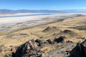
Retreating water levels on the Great Salt Lake.
During dust storms, host spots on the lake will pop and emit swirls of dust, collecting particles less than a fraction of the width of a human hair, darkening the sky and propelling them into communities nearby. The smallest particles can remain airborne for weeks at a time.
The lake bed contains pollutants like arsenic, distributed widely across the surface, which could be an indication that some of it occurs naturally, Perry said.
The lake has long been a catchment for industrial pollution. Each area of the lake has its own recipe of toxic metals and other substances, fed by different polluting industries nearby. Researchers are concerned that what’s been stored in the lake will soon be carried on the wind into Salt Lake City and other neighboring communities.
About 9% of the lakebed was a dust source as of 2018, he said. A protective crust covers other areas of the lake, but it’s being broken down by wind and weathering.
“The longer the lake bed is exposed, we expect that to increase. It could increase to 24% to 25% of the lakebed,” Perry said.
This isn’t a problem caused by climate change; Utahans are simply consuming too much water for agriculture, industry and residential use from the overtaxed rivers that feed the terminal lake. Modeling suggests human water diversion has reduced the lake level by about 11 feet, the Utah State research shows. Meanwhile, increased evaporation due to climate change has caused the lake level to drop less than half a foot.
Lawmakers in Utah — the “industry” state — have begun to turn their attention to the lake, passing a series of bills designed to revamp how the state uses its water. Utah Gov. Spencer Cox in November closed the basin to new water appropriations. But for years, the lake was an afterthought in the state’s unslakable thirst for economic growth.
“The entire state has an unhealthy relationship with water,” Perry said. “We need to start living like we live in the desert.”
Researchers still don’t understand exactly where the dust ends up, whether its toxic metals are being easily absorbed into people’s bodies and what risks that might pose. To try to answer some of those questions, scientists with the U.S. Geological Survey in 2018 and 2019 installed 18 dust traps throughout the Salt Lake City area.
The traps were left out for months and captured everything: dust from the lake, from local construction and from nearby deserts.
When they examined the dust, researchers found some interesting storylines.
“We’ve got some bells going off,” said Annie Putman, a USGS hydrologist who led the study. “The pieces are there to think we should be concerned.”
Traces of arsenic, lead and other toxic metals were discovered across the sites, according to the findings, which were published in the journal GeoHealth in late October.
At every site, concentrations of arsenic were enough to exceed an Environmental Protection Agency marker of concern for residential soil. One site had a concentration 35 times higher, though it’s not clear how that translates to risk for human exposure.
The Bowl
Salt Lake City, often associated with ski slopes that gleam above the city skyline, developed a reputation for air pollution long before dust grew as a concern. Of 888 U.S. metro areas, it ranked the ninth-highest in an EPA risk screening that modeled health risk from toxic chemical releases in 2020, and 20th for short-term particle pollution last year by the American Lung Association.
The pollution burden is felt unequally among residents.
John Lin, Atmospheric Research Professor.
Mountains cradle Salt Lake City on three of its sides. Its fourth border — to the west — leads to the brackish-smelling shores of the Great Salt Lake. Interstate 15 slices the city in half, dividing east from west. On the east side, well-to-do homes sprawl toward the canyons, gaining in elevation.
Housing in neighborhoods that make up the “west side,” as Salt Lake residents call it, commingle with refineries, a wastewater treatment plant, highways, railways and a busy airport. The neighborhoods are typically less wealthy, less white and historically redlined — the west side was deemed a “hazardous” real estate investment in the 1930s by the federal Home Owners’ Loan Corp.
These neighborhoods are closer to the valley floor, where the lion’s share of the air pollution can be found.
“If you look at Salt Lake, it’s essentially a bowl and the dense emissions are in the lower elevations,” said John Lin, an atmospheric research professor at the University of Utah.
And with the exception of ozone, pollutants such as black carbon, nitrogen dioxide and particulate matter “tend to be higher in lower-income neighborhoods, places with nonwhite populations,” Lin said.
In summer, concern centers on wildfire smoke and ozone. Spring and fall were once respites. But now, those seasons are turning to dust.
In the winter, the word “inversion” is a dirty word for Salt Lake residents. During an inversion, a layer of warm air settles over the valley like a lid for the bowl, trapping everything below as if it were a cap.
Daniel Mendoza, assistant professor of atmospheric sciences.
“The pollution builds up a hot spot and doesn’t blow away,” said Daniel Mendoza, an assistant professor of atmospheric sciences at the University of Utah.
Neighborhoods higher in elevation — more often above the inversion’s cap — are typically less impacted as pollution builds. But on the west side, closer to many sources of pollution, residents can get stuck in a thicker pea soup of car exhaust, refinery emissions and other pollutants.
“It irritates the eyes and gives me sinus infections,” said Jorge Casillas, 58, who has lived on the west side for 15 years. “It’s hard to be trapped in the valley.”
Overall, emissions have improved in Salt Lake City, mostly because of vehicle emissions standards enacted by the Obama administration’s EPA, according to Perry. The EPA in 2021 proposed re-listing the Salt Lake City area as in “attainment” for small particle pollution it had been failing to sufficiently control.
“When we switch to electric vehicles, our air quality is going to improve dramatically,” Perry said.
But wildfires and dust storms off Great Salt Lake are erasing the progress that has been made. For those in the West Side, it adds a new layer of concern for their health.
“There’s so much sediment and so much trapped for so long. It’s pulling up stuff that’s been trapped for 100 years,” Casillas said. “Are there carcinogens or other health risks? That’s what I’m worried about. There’s so many children in the neighborhood.”
A drumbeat of media coverage over dust and pollution has frightened some Utahans.
“I’ve received a number of emails from concerned citizens reconsidering living in Salt Lake City,” said Janice Brahney, an assistant professor at Utah State University’s watershed sciences department.
"We don’t know"
When USGS researchers mapped the samples collected from their dust traps, they found something interesting.
While other metals such as nickel, thallium and lead were more likely to exceed those EPA markers in poorer, less-white communities like Rose Park, arsenic was more concentrated in samples from wealthy communities, possibly because of its past use as a fertilizer on agricultural lands.
The researchers suspect that urban, diverse neighborhoods are receiving much of their dust and the toxic metals within that dust from local sources — nearby polluters or construction projects. It’s also possible that dust from the Great Salt Lake and other nearby playas picks up local pollutants from nearby mines, refineries and pesticides as dust travels into the city.
Meanwhile, researchers found the highest levels of dust — and metals — in suburbs outside urban Salt Lake City. Researchers suspect communities north of the city, including areas such as Syracuse, Ogden and Bountiful could be receiving the majority of the dust that blows off the lake. In early October, less than a mile from what was once lakeshore, workers were hammering away to frame new housing.
These areas are an air monitoring dead zone, Perry said.
“There’s almost no sampling done north of Salt Lake City,” he said. “We’re really lacking a coherent network to answer the question of who is impacted the most.”
Annie Putman, USGS researcher.
Putman and colleagues this year set up another 17 dust traps — all nicknamed “Woody” — in counties north of Salt Lake to better evaluate the risk for those areas.
So much remains unknown. While the EPA has screening levels for metals in soil, no environmental standards exist for exposure to toxic metals contained in dust.
“How much arsenic does there have to be over a 24-hour-period for dust to cause problems — we don’t know. We don’t have any study that can tell us that,” Putman said. “What are the short- term or long-term consequences of that? We don’t know at all.”
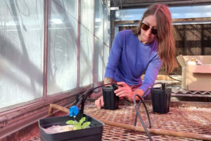
Researchers are also unsure if the arsenic and other metals in the dust are “bioavailable” — meaning they can be absorbed into plants, animals and humans. Testing is ongoing. Blakowksi is growing cabbage in a laboratory and sprinkling the plants with dust samples from the Great Salt Lake to see how much arsenic they take up.
In California, ratepayers have spent about $2.5 billion controlling dust emissions on Owens Lake, which was drained by the Los Angeles Department of Water and Power only to become the biggest humanmade source of dust in the U.S..
Researchers say the Great Salt Lake represents a much larger threat.
“The area of currently exposed lakebed is over seven times larger than the entire area of Owens Lake,” Blakowski said, adding that the population downwind is about 50 times larger in Utah’s case. “We can’t wait. It’s just going to keep getting dustier and there are serious human health and ecosystem implications if we sit on this too long.”
Bonneville Salt Flats

Jeremiah Bernau
The race to save Bonneville Salt Flats.
In the Utah desert, a treeless expanse of pristine white salt crystals has long lured daredevil speed racers, filmmakers and social media-obsessed tourists. It's so flat that on certain days, visitors swear they can see the curvature of the earth.
The glistening white terrain of the Bonneville Salt Flats, a remnant of a prehistoric lakebed that is one of the American West's many other-worldly landscapes, serves as a racetrack for land speed world records and backdrop for movies like "Independence Day" and "The World's Fastest Indian."
But it's growing thinner and thinner as those who cherish it clamor for changes to save it.
Research has time and again shown that the briny water in the aquifer below the flats is depleting faster than nature can replenish it. As nearby groundwater replaces the mineral-rich brine, evaporation yields less salt than historic cycles of flooding and evaporation left on the landscape.
It's thinned by roughly one-third in the last 60 years. The overall footprint has shrunk to about half of its peak size in 1994. The crust keeps tires cool at high speeds and provides an ideal surface for racing — unless seasonal flooding fails to recede or leaves behind an unstable layer of salt. Racers struggle to find a track long enough to reach record speeds with only 8 miles of track compared to 13 miles several decades ago.
Scientists largely agree that years of aquifer overdraws by nearby potash mining have driven the problem, yet insist that there's no hard evidence that simply paying the mining company to return water to the area will solve it amid detrimental human activity like extracting minerals or driving racecars.
Potash is potassium-based salt primarily used throughout the world as a fertilizer for crops such as corn, soy, rice and wheat. It's extracted in more than a dozen countries throughout the world, mainly from prehistoric lakebeds like Bonneville's.
It's mined from other iconic salt flats, including in Chile, where the thickness is not shrinking in a similar manner.

Collecting water samples near Wendover, Utah, Sept. 13, 2022. (AP Photo/Rick Bowmer)
In Utah, after three decades of studies examining the salt flats, nothing has slowed the deterioration. But officials are funding a new study as they try to find a solution. Researchers are seeking to pinpoint why the salt is fading and what can be done to stop it. Under a $1 million research project spearheaded by the Utah Geological Survey, scientists are gathering data to understand the effects climate change, racing, repaving the salt and operating the mine on leased federal land have on preserving the Salt Flats.
The salt is thinning as climate change drags the West into its third decade of drought, yet it's unclear how that affects the seasonal flood patterns the landscape relies on to maintain its size and footprint.
Frustration is boiling over for Dennis Sullivan, a car-builder and racer who set a land speed record in his 1927 Model T street roadster. His organization, the Salt Flats Racing Association, is convinced the potash mining company that extracts minerals from the flats is the primary reason that the aquifer is being depleted. But rather than point fingers that direction, he and other racers blame the U.S. Bureau of Land Management, which oversees the area and is required by federal law to balance multiple uses and preserve it now and into the future.

The Blue Flame at Bonneville Salt Flats on Nov. 4, 1970.
To save the landscape, Sullivan says, the U.S. government needs to find $50 million over 10 years to pay Intrepid Potash, the mining company, to pour briny water it's drawn from the land back on to the flats. He bristles at seeing more time and money spent on research when to him the solution is clear.
"In the world I came from, you study something, you figure out what changes you need to make, you make the changes and then you go back and study it again to see if your changes had an effect on it," said Sullivan. "It's ludicrous to just keep studying it until you do something."
The fragile landscape has become less reliable for racers, who had to cancel "Speed Week" events scheduled for this fall after the salt flats flooded and left them without enough space to drive on.
Though racers insist the answer is obvious, scientists contend that there's no hard evidence that simply returning briny water will reverse the effects of extraction and maintain the salt flats.
Sullivan doesn't blame Intrepid Potash; it has a leasing agreement with the federal government. He says land managers haven't invested in preserving the landscape or replenishing the salt taken off of it.
Intrepid Potash did not respond to questions from The Associated Press.
Jeremiah Bernau, a geologist working on the study with the Utah Geological Survey, said the mining company has already been pouring salt and it's unclear if that's the answer.
A 2016 study found that the areas most susceptible to thinning were places where races are organized. In simple terms, it changes how water can flow through the crust, Bernau said.
"Every use is going to have some sort of impact upon it. It's just trying to rank those, understand how much that impact is and what we can do to mitigate or understand it," Bernau said on a recent tour of the area, where reporters accompanied him as he measured the thickness of the salt and depth of the aquifer.
"My work is trying to understand how is that working and what are the actions that we can do in terms of helping to preserve this landscape," he said.
Backers of the study currently underway hope, if successful, the federal government will consider returning more salt in order to preempt conflict and allow the racers and miners to continue as they have been.
If the study shows salt laydown is effective, Utah state geologist Bill Keach said he expects racers will use the information to push for federal funding to keep up the project.
In 2019, when Utah lawmakers greenlit the initiative, they allocated $5 million, on the condition that the federal government would also provide funding, to return the briny water needed to preserve the salt crust.
Rep. Steve Handy, a Republican who spearheaded the effort, said the racers' lobbyists initially suggested the federal government would meet Utah's investment with an additional $45 million, giving the program the $50 million that Sullivan and other racers say is needed to maintain the status quo.
U.S. Rep Chris Stewart, who represents the area, assured Handy his office was working to secure the funds. Without hard evidence the salt laydown would restore the crust, the $45 million hasn't materialized but Stewart said in a statement that he "remains absolutely committed to finding science-based solutions" to save the crust.
Utah clawed back the majority of the funding after it got no matching federal funds.
"They're doing what they can with $1 million, which has not spread nearly far enough," Handy said, noting that it was ultimately the job of the federal government, not Utah, to manage the land.
But while solutions and the extent to which different parties are responsible is debatable, nobody disagrees that the landscape is a jewel worth preserving. Kneeling down, the crust of fused crystals looks like popcorn. From afar, the surface is moon-like, and draws hundreds of visitors daily, some coming in brightly colored dresses at sunset in search of the perfect picture.
"The fact that you can go out here and see this vast, white expanse with such a beautiful texture on the crust. It unleashes something, maybe more primal in yourself," Bernau said, looking off into the distance.
Wilkes Climate Prize
Construction Update
Construction is about to begin on the University of Utah’s new Applied Science Project. The project will restore and renovate the historic William Stewart building and construct an addition to the building on the west side, adjacent to University Street. Construction will start in early October.

Construction Timeline
This important project will provide new and updated space to serve the University of Utah’s educational and research mission. It will serve as the new home for the Departments of Physics & Astronomy and Atmospheric Sciences, focusing on aerospace, semiconductor technology, biotechnology, data science, hazardous weather forecasting, and air quality. Together, the two departments teach more than 5,600 students. See why the University of Utah College of Science is so excited about launching this project.
New construction will provide a 56 percent increase in experimental and computer lab capacity. There will be 40,700 square feet of renovated space in the historic Stewart Building and a 100,00 square foot new addition. The project will preserve and restore the historic character of the William Stewart Building while introducing a modern yet complementary design for the new addition. The new building’s exterior finishes will resemble the latest addition to the Crocker Science building next door.
Tree protection plans are in place, and the project team has taken steps to ensure the safety and preservation of Cottams Gulch, which will remain open and accessible during construction. In addition, the project team is working with Simmons Pioneer Memorial Theater leadership to ensure construction does not affect theater activities.

Cottam's Gulch